
Introduction & Objectives
Harbor seals (Phoca vitulina) are one of the world’s most widely distributed pinniped species and are found in temperate to polar coastal waters of the northern hemisphere (Jefferson et al. 2015). Gray seals (Halichoerus grypus) are widely distributed over the continental shelf in cold temperate and sub-polar North Atlantic waters (Lesage and Hammill 2001). Both species are year-round coastal inhabitants in eastern Canada and New England and occur seasonally in the mid-Atlantic United States between September and May (Hayes et al. 2023). Individuals of both species move to northern areas for mating and pupping in the spring and summer and return to southerly areas in the fall and winter.
Since 2014, NAVFAC Atlantic has been conducting haul-out surveys in Virginia to determine habitat use, seasonality and abundance at several locations near Hampton Roads Navy installations and the offshore Virginia Capes operating area. Vessel surveys are highly dependent on weather, marine conditions, and survey crew availability. Due to these limitations, there is limited flexibility to collect data where there is a paucity of information (e.g. times near sunrise/sunset and in adverse weather conditions).
Camera traps have proved effective for monitoring wildlife in remote locations and with limited impact to the animals (Wearn and Glover-Kapfer 2019, Koivuniemi et al. 2016). In combination with the data previously collected at the known haul-out locations, camera monitoring, which is near continuous, will provide a more complete picture of the seasonal occupancy in Hampton Roads. This level of baseline data will allow for the detection of changes to the local population over time.
Objectives for this study are to improve the understanding of local haul-out numbers and behavior to include any haul-out patterns in relation to environmental factors. Data collected will improve the assessment of potential impacts from Navy training and testing activities as required under the Marine Mammal Protection Act and National Environmental Policy Act for USFF and CNIC-funded projects in Hampton Roads Virginia.
Hayes, S. A., Josephson, E., Maze-Foley, K., Rosel, P. E., McCordic, J., & Wallace, J. (2023). U.S. Atlantic and Gulf of Mexico Marine Mammal Stock Assessments 2022 (52071; NOAA Technical Memorandum NMFS-NE; 304). NOAA. https://doi.org/10.25923/42zk-w456
Jefferson, T.A., Webber, M.A., and R.L. Pitman. 2015. Marine Mammals of the World: A Comprehensive Guide to Their Identification, Second Edition. Academic Press, San Diego, CA
Koivuniemi M, Auttila M, Niemi M, Levänen R, Kunnasranta M. Photo-ID as a tool for studying and monitoring the endangered Saimaa ringed seal. 2016. Endang Species Res. 30:29–36.
Lesage, V. and M. O. Hammill. 2001. The status of the Grey Seal, Halichoerus grypus, in the Northwest Atlantic. Canadian Field-Naturalist, 115(4): 653-662.
Wearn O., and Glover-Kapfer P. 2019. Snap happy: camera traps are and effective sampling tool when compared with alternative methods. R. Soc. open sci. 6:181748
Technical Approach
Trail cameras are installed at ten different Virginia haul-out sites in two different survey areas 1) in the lower Chesapeake Bay at the Chesapeake Bay Bridge Tunnel (CBBT) islands, and 2) on the southern tip of the Eastern Shore.
Each camera records images throughout the local seal occupancy season from October through May. Cameras are placed to provide maximum coverage of the known haul-out locations at the Eastern Shore area, and the two highest use areas of the CBBT. Images are recorded during daylight hours at a frequency of every 15 minutes. The number of seals hauled out and in the water and the presence of vessels are recorded in each image. Data are then analyzed for correlation to local environmental variables.
Progress & Results
Remote trail cameras have been deployed at two sites in southeastern Virginia (on the Eastern Shore of Virginia & on the Chesapeake Bay Bridge Tunnel (CBBT) islands) for six complete field seasons as of 2025. Seasons run from mid-October to late-May. For the 2024/2025 season, three infrared time-lapse cameras were also deployed at one of the Eastern Shore haul-out sites and night images were collected to look at diel haul-out patterns. Over 460,000 images have been collected from all five seasons and have been processed using Timelapse2 computer software.
Seals have consistently been observed from October to late April/mid-May and are recorded in the highest numbers during the months of January, February, and March. While the vast majority appear to be harbor seals, gray seals were positively identified in 94 different images across the first 5 seasons. Seals have been observed hauling out in higher numbers at the Eastern Shore site versus the CBBT. Seals have also been observed hauling out in higher numbers when tidal height was between 0 and 2 feet at the Eastern Shore and between -1 and 1 feet at the CBBT; at lower wind speeds; and at air temperatures around 50°F. There was a significant negative correlation between the number of seals that were hauled out and tidal height at the Eastern Shore, wind speed at both survey areas, and air temperature at both survey areas. However, there was not a significant correlation between hauled out seals and tidal height at the CBBT.
For the 2024/2025 season at the Eastern Shore survey area, daytime and nighttime maximum counts were assessed at one main haul-out site to see if there were any diel haul-out patterns. Results revealed that generally higher monthly maximum counts were recorded at the site during the daytime, with the exception of November and December. Overall, there was an average of 13 seals hauled out during the day and 11 seals at night for the season. Median values for day versus night were similar, with 11 and 10 seals, respectively.
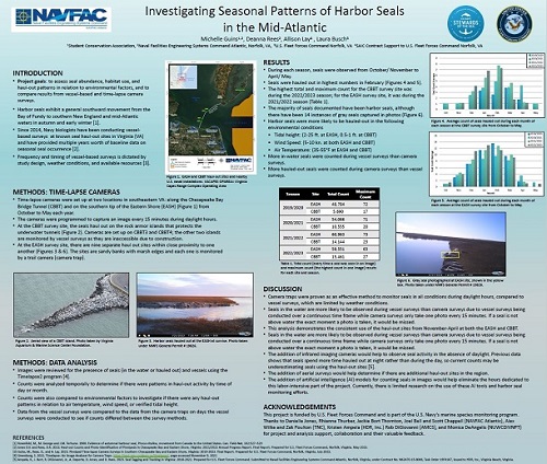
Below is the poster presented at the 2024 National Military Fish and Wildlife Association Annual Meeting in Grand Rapids, MI.
Project Information
Timeline
2019-ongoing
Location
Lower Chesapeake Bay and Eastern Shore of Virginia
Visual surveys, focal follow observation, morphometrics, photo ID, biopsy sampling, satellite tagging
Principal Investigators
Principal Investigator
Danielle Jones
NAVFAC Atlantic
Environmental Conservation, Marine Resources Section
Co-Principal Investigators
Rhianna Knerr
NAVFAC Atlantic
Environmental Conservation, Marine Resources Section
Zak Poulton
The Nature Conservancy
Virginia Coast Reserve
Previous PI and Project Managers
Deanna Rees
NAVFAC Atlantic
Environmental Conservation, Marine Resources Section
Michelle Guins
NAVFAC Atlantic
Environmental Conservation, Marine Resources Section
Sponsor(s) & Funding
Total - $205k, FY26 - $20k
Point of Contacts
Danielle Jones
NAVFAC Atlantic
Environmental Conservation, Marine Resources Section
